Siberia - forgotten continent
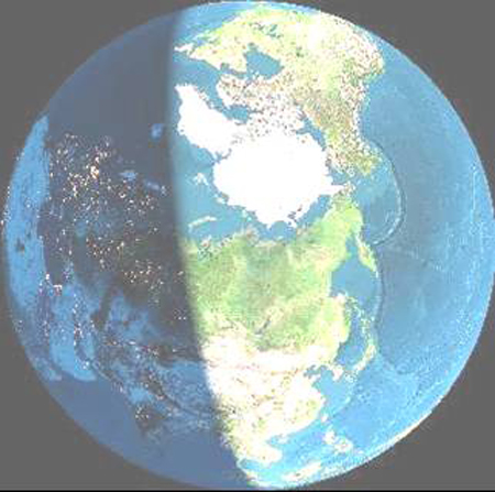 Siberia is so big that you cannot see it all at the same time from space. In this (artificially enhanced and coloured view - no clouds) it is still night in the south-western part, you can see the lights of the towns.
Siberia - forgotten continent
Siberia is so big that you cannot see it all at the same time from space. In this (artificially enhanced and coloured view - no clouds) it is still night in the south-western part, you can see the lights of the towns.
Yakutia, now the Sakha Republic, is a country in North East Asia, the size of most of Europe. Russians exploring Siberia at the beginning of the 17th century first heard about the country from people who were calling it the far off land, so that it what the name Yakutia really means.
It was given this name by the Russians who first arrived there in the early seventeenth century lured by tales of a civilized people with lots of silver. They named the people Yakut and their capital city Yakutsk. The Yakuts called themselves the Sakha, and their capital Saksary. In 1991 Yakutia became the Sakha Republic (but part of the Russian Federation).
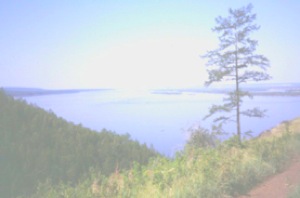
The River Lena is central to Yakutia, it is a main route along which inhabitants migrated, and along which people may have settled as much as two millions years ago.
Rosa Bravina, who was Professor of Ethnography at Yakutsk University and a white shamaness, told me Yakutia has four corners.
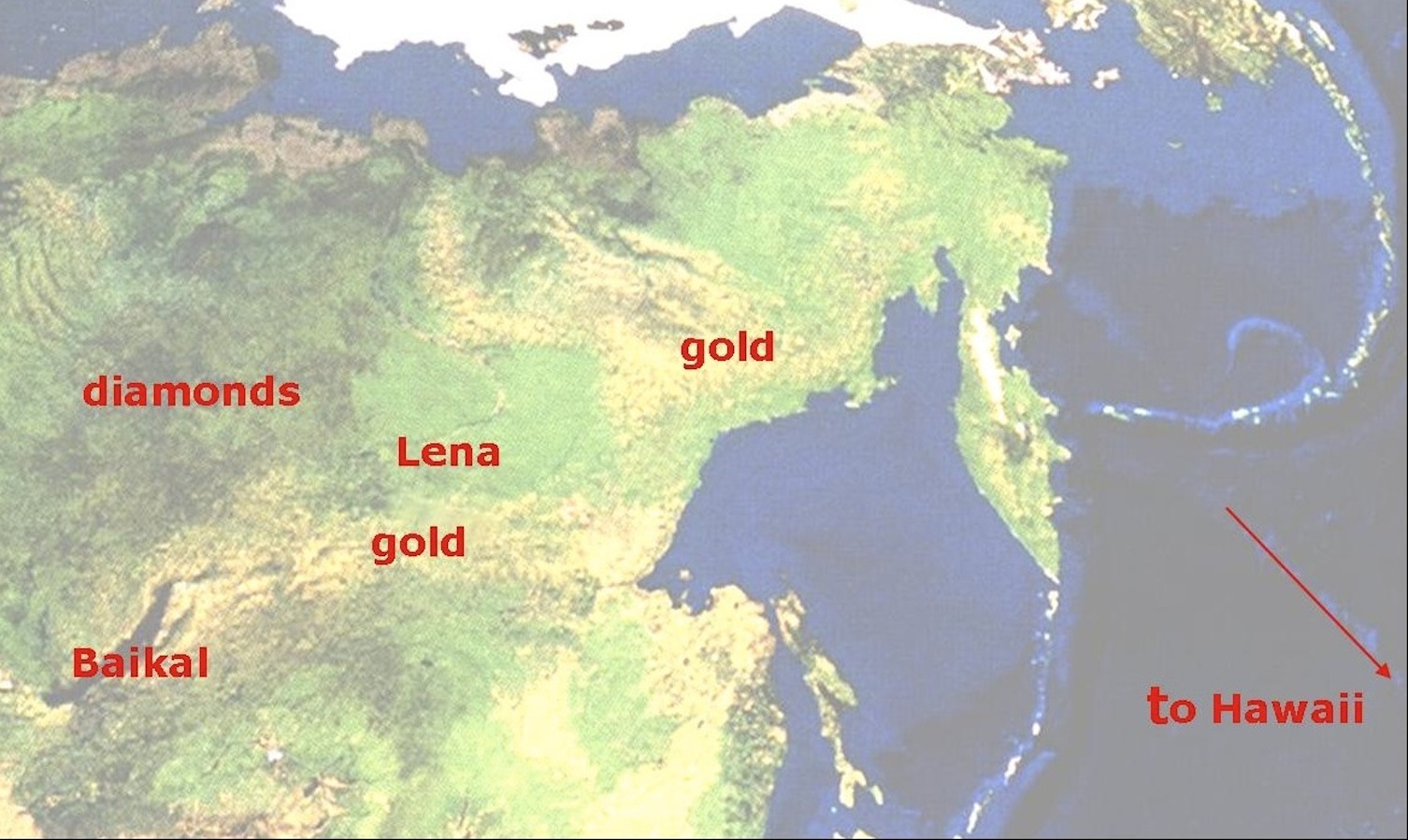
She pointed them out on a map. Indicating a diamond shape with points to the north, west, east and south. The north corner up by the Lena delta, and the shores of the Arctic Ocean, this is Bulun region. The west corner is Vilyuy where the diamonds come from (and Rosa's birthplace). The south corner is Lake Baikal, and the East is the Okhotsk sea and the Pacific Ocean.
When I pointed out that the borders of Yakutia did not in fact reach to Baikal, and to the Pacific coast, I was told firmly, that they should do. In fact they did, until in the 1930s, the Soviet Union appropriated the regions with the gold mines.
 . A satellite view of the North Pacific shows that around the Pacific coastline are chains of islands looped like necklaces. The Aleutians linking Kamchatka with Alaska, further south, the chain of islands from Sakhalin which form Japan. These are characteristic for places where one part of the Earth's crust is pushing under another - in this case the Pacific Ocean is disappearing under these islands. Gradually these loops of volcanic islands become attached to the mainland. You can see where this has already happened by the shape of China, and further south, Vietnam, Cambodia, and Thailand.
From the satellite's view, a chain of underwater volcanoes can be seen linking Kamchatka to Hawaii. These show how the Pacific has moved north over a hot spot. This is a place in the Earth's crust, where the heat in the centre of the Earth erupts to form volcanoes. The result is the islands of present day Hawaii, with the new volcano forming at one end while the older ones in the chain slip back.
Yakutia contains one of the oldest parts of the Earth's crust. This was once a volcanic island over a hot spot in the Earth's crust, rising out of the shallow seas which covered the Earth in its early history more than four billion (4 x 1,000 million) years ago.
This is one of the few pieces of the original continents to have survived the massive catastrophe that occurred to the solar system about 3.9 billion years. (Other known bits of the original Earth's crust are in South Africa and Greenland.)
When the solar system settled down again, it was similar to what is looks like today, and the Earth had a acquired a large moon. The gravitational pull of the moon has been slowing the Earth's rotation, and keeping the Earth's axis at a steady slight tilt which controls the climate to some extent.
Life - single celled, was already present in the rock which was to become not just Yakutia, not just Siberia, but the whole Eurasian continent.
About 650-700 million years ago, another event disturbed the Earth and its neighbour in space Venus. A massive disturbance to Venus caused such volcanic activity that whole surface was completely re-surfaced - if there had been water and life on Venus - and there may have been - it was destroyed and it may have been then if not earlier, that Venus became the lifeless, steamy, hot smelly (sulphurous) planet is is now. At the same time there was a massive extinction event on Earth. 70 percent of the single celled life forms which then existed were destroyed, the climate became cold and Earth was covered by ice.
At this time there were three main continents on Earth - "Northern Gondwanaland" (India, Antarctica, Australia), "Southern Gondwanaland" (Africa, North and South America) and Siberia or at least that part which forms central Yakutia today. All were covered in ice.
When this glacial event over, the first multicellular life forms had evolved, including creatures looking like jellyfish. They lived by the shores of Yakutia. As seas pushed chains of volcanic islands into the small island continent and it grew larger with each chain of mountains, each dried up sea bed with fossils between. At the same time it was gradually pushed north from its position near the south pole. This period is called the Vendian age.
The Vendian age came to an end about 540 million years ago with another extinction event and glaciation. When the ice melted again, new life forms emerged many protected by shells or shelly hard bodies. The Cambrian age. During which Siberia was a great island continent basking under equatorial sun with fantastic creatures swimming around its shores. Slowly the seas pushed it towards the north. (More on the early history of Earth).
 Yakutia was getting near its present position to the east of Europe then attached to the north end of the great continent of Pangea, 250 million years ago.
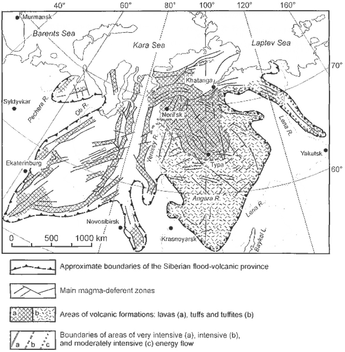
Yakutia was passing slowly over a hot spot on the Earth's crust, when possibly an asteroid impacted in the ocean other side of the Earth. The shock waves caused a massive surge under the weakness in the Earth's crust tearing what is now the west of Yakutia and central Siberia apart with volcanic eruptions and flows of lava over a vast area - nearly 4 million square kilometres, called the Siberian Traps (see above diagram).
Dust thrown in the air blotted the sun's warming rays for at least a million years, causing an ice age and triggering off other major climatic disturbances and geological events. Methane released under the seas killed marine life.
The huge continent - even larger as it became joined by what was now becoming the continent of Asia, turned into an icy desert. About 90 per cent of the existing life on Earth, plants and animals died. It was the biggest extinction event the Earth has suffered.
 As surviving life evolved to cope with the changing climatic conditions, the first warm blooded animals emerged. Western Siberia became seamed to Europe down the Ural Mountains and more of Asia attached itself to the south of Siberia, thrusting up mountains and the gold within them.
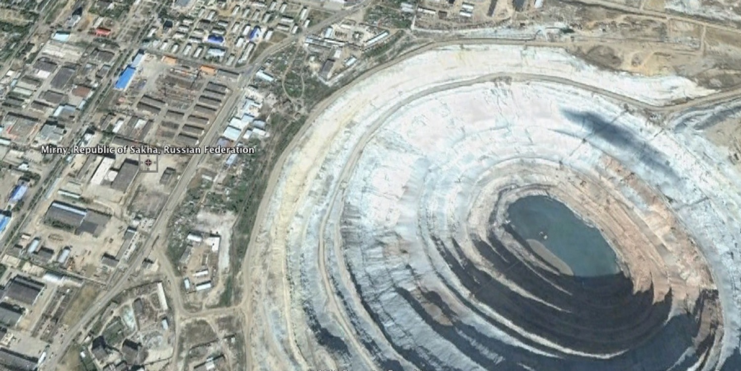
The massive eruptions to the west of Yakutia left a rich legacy of diamonds - Yakutia is the second largest producer of diamonds in the world.
The picture shows one of the diamond mines in Mirny by the Vilyuy River. The town was built right next to the open cast mine seen in this Google Earth view. You can get an idea of its size from the blocks of flats nearby. More on the diamonds later.
 East of the River Lena are mountains. This is a much faulted disturbed region. About 100 million years ago, a great volcanic rift started to split what is now Africa from South America, and continued north to push apart North America and Greenland from Europe. (Leaving a bit of Newfoundland on top of Scotland).
The Atlantic ocean was formed and continues to spread apart a few centimetres each year, along the central volcanic ridge which can be seen on the surface where it passes through Iceland.
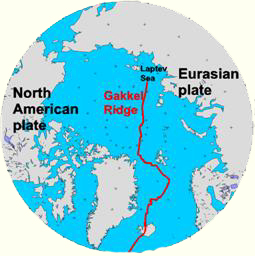
It does not stop at Iceland. This massive fault creating new ocean floor and land, continues as the Gakkel Ridge (diagram right) across the Arctic Ocean to hit the continental shelf in the Laptev Sea, off the coast of Yakutia east of the Lena Delta.
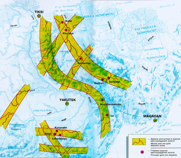 This fault continues across the continent, west of the river Lena. It creates the mountain ranges of the Kolyma region - throwing up gold as it does so. It reaches the Pacific ocean at Okhotsk. This forms a corner. For the fault splits two ways, across the bay of Okhotsk, one end continuing down to Sakhalin and Japan to meet the Pacific. It also joins the seam which marks the south of Siberia, to which the southern part of Asia is joined.
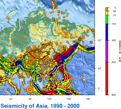 This creates a complex geology. Since the contents of America and Eurasia were being pushed apart on the other side of the globe, by the time the fault crosses Yakutia, it cannot push them apart for they have to go somewhere so this marks the boundary where the continents of Eurasia and America are pushing against and thrusting past each other. This can be seen in the relief map (right) showing earthquakes from 1990 to 2000.
The eastern part of Yakutia and Northern Asia is actually part of the North American plate.
 All this complex seismic activity has thrown up valuable minerals, the most famous being gold, in the east and southern parts of Siberia. More on the gold mines and the Gold.
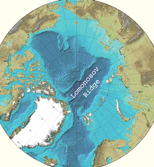 Today the Arctic ocean is always covered by ice, which only melts around the north coast of Siberia for a few weeks at the height of summer. Around 45 to 55 million years ago, the Arctic Ocean was a warm shallow sea with a climate, supporting the sorts of plants and creatures associating with a warm tropical or nearly so, climate. This was at a time of global warming, when the amount of carbon di-oxide in the atmosphere was far higher than it is today. At this time Siberia reached as far as the Lomonosov Ridge - a now underwater mountain chain which stretches across from just east of the Lena delta to Greenland.
These discoveries revealed by cores through the ice and sediments are not only interesting but relevant today - as over the past 30 years, the polar ice has thinned and carbon di-oxide levels have risen. Since the Arctic Ocean plays an important role in the global climate system, these studies are critical today. The cold current from the Arctic ocean, drives the ocean conveyor belt - of continuous currents around the planet.
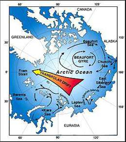 Ice forming on the shallow Laptev Sea near the Lena Delta drifts across the North Pole to the Atlantic Ocean. After two or three years it has drifted south enough to melt into the sea and all it contains including pollution becomes part of the seas washing Britain's coasts and the air blown over it. Update: in this paper. So monitoring air and sea is very important and there are scientific surveys and a scientific station on the tundra at Tiksi. The ice of the Laptev Sea affects the ocean currents and climate all over the world.
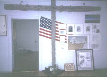 The drift stream was discovered after the Jeanette disaster in 1879. (Described later). There is a memorial display in the museum at Tiksi. The Jeannette had become trapped in the ice. Years later its wreckage was found off the south of Greenland. Fridtjof Nansen decided to check this drift with his ship the Fram, in 1893. In 1994 an expedition intended to make use of the ice drift to walk to the North Pole, and raise funds for the Save the Children fund at the same time. But they had to be rescued without achieving their goal.
Baikal, the inland sea, south of Yakutia, is so deep it goes down to molten rock. It is part of the disturbed mountain region of faults which resulted as India started pushing into Asia a few million years ago, throwing up the Himalayas, affecting the climate of south-east Asia - and the rest of the world. Only the Angara River feeds into it. There is a romantic legend to explain this, but the real reason is not clear. The Lena River looks like it should go into Baikal, but neither the river not its tributaries reach it.
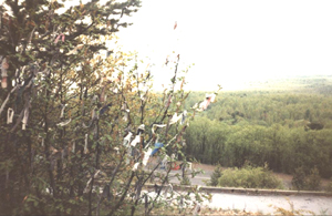
 Baikal is a place of myths, legends and magic and history. It is the birth place of Genghis Khan. The main population of this region is Buryat Mongol. Also Tungus (Evenk). There is a strong Chinese influence here on the borders, and major ancient trade routes. The main religious beliefs were shamanist. Presbyterian missionaries made a small impact in the 19th century, but were rivalled by the spread of Buddhism. Picture on left shows a sacred place where people tie strips to the trees, just as they do in such places in Britain.
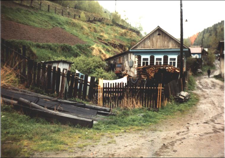
Picture on right shows a typical house. The older houses were made of larch which lasts more than 300 years. They had a sauna, but no toilet. People used the duck yard. Now there are regulations for sanitation which can still be rather primitive.
Baikal is a place of myths, legends and magic and history. It is the birth place of Genghis Khan. The main population of this region is Buryat Mongol. Also Tungus (Evenk). There is a strong Chinese influence here on the borders, and major ancient trade routes. The main religious beliefs were shamanist. Presbyterian missionaries made a small impact in the 19th century, but were rivalled by the spread of Buddhism. Picture on left shows a sacred place where people tie strips to the trees, just as they do in such places in Britain.
Picture on right shows a typical house. The older houses were made of larch which lasts more than 300 years. They had a sauna, but no toilet. People used the duck yard. Now there are regulations for sanitation which can still be rather primitive.
And Baikal is also one of the places on Earth where they look for neutrinos.
At the centre of a vast continent, Yakutia, especially around its capital city, Yakutsk, is under a permanent atmosphere high pressure zone, and experiences an extreme continental climate. Short hot summers (up to 40 degrees Celsius) are followed by long cold winters. In the mountainous region of Kolyma winter temperatures may plummet to be the coldest in the world. Omyakon boasts the coldest ever recorded temperatures of all - minus 72 degrees.
As there is always atmospheric high pressure, there is not very much cloud cover, and snow in winter, so the ground has frozen to record depths, more than anywhere else in the world.
Microorganisms have been searched for in the permafrost as the conditions are similar to those that might exist on Mars and Europa and there is a possibility that life forms of this kind could exist on those worlds.
The frozen ground is called permafrost and causes a number of distinctive features on the ground and a number of problems. The ground cracks forming polygonal shapes. These features are marked by small streams, and water-loving plants. The land in the middle is called a pingo. It may stay flat or rise into a hill, or sink into a pond. Permafrost land is dotted with little round lakes and many streams.
The boggy ground in summer is joy for mosquitoes. It may be hot - but the wise remained covered up from head to foot. Traditionally, protective net clothing was part of essential summer wear. Smoky fires were lit to drive the pests away. It is too far north for malaria - although global warming may change that. But you can get horribly bitten.
During the summer, the ice in the soil will melt more around any objects like trees, posts etc. than the surrounding ground in the summer. This leaves a gap around the tree, which is later infilled with snow, and wind blown debris. Long after the tree has gone, this leaves a permanent feature in the ground, which is called an ice wedge. In the layers of ancient permafrost, which in Yakutia can be dated back two million years, these ice wedges can be seen. Their presence shows that the winters at the time had freezing temperatures.
The ground under and around buildings will also thaw and become soft and boggy. This causes massive subsidence. Buildings collapse, roads crack up.
Traditionally people got around such problems by abandoning their warm winter home, when summer arrived, as it had sunk into a boggy morass. In the hot summer days with 24 hour sunshine they could live in a tent. But in autumn they had to build a new winter house or they would not survive. Hard surfaced roads are impossible to maintain. Roads are broken up, and even in cities are bumpy gravel or other permeable material or just mud with bones (of reindeer or cows) sticking in it. Transport depended mainly on the rivers until light aircraft offered an alternative.
Distances were measured - as in North-East India by the Kyoss. This was the distance you could travel in the length of time it took to boil a kettle of water. There was a winter and a summer Kyoss. In summer you got bogged down in the mud. In winter the ground was frozen so you travelled faster.
 Services are carried in pipes above ground. You have to climb over the pipes, protected by wooden boards and lagged with reindeer fur. Homes have outside winter toilets.
This photo was taken in 1993 in the centre of Kyusyur a town by the Lena within the Arctic circle.
Services are carried in pipes above ground. You have to climb over the pipes, protected by wooden boards and lagged with reindeer fur. Homes have outside winter toilets.
This photo was taken in 1993 in the centre of Kyusyur a town by the Lena within the Arctic circle.
In Yakutsk there is the Permafrost Institute which was founded to investigate problems of building on permafrost.

All new buildings have to wait for pillars to be driven into the ground first, and left to settle. Then the rest of the building, flats, offices etc. is constructed upon these leaving an empty gap - only big enough for a rat run, between the lowest floor and the ground.
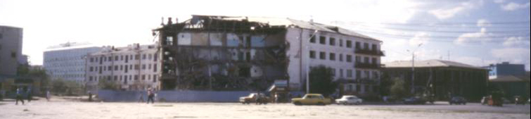
Even then buildings still collapse. In 1993, when I was in Yakutsk for the first time I said "I didn't know you had a war recently - there was nothing about it in England." "We had no war" they told me. "Only some student's riots in the 1980s". "What happened there - then" - I pointed across Orkonidze Square - the main square of Yakutsk, with bus station, post office, shops etc. Opposite looked like a bomb site. "That building fell down" I was told.
In spring when the ground melts, it becomes boggy. The ice melts on the rivers, but as the rivers flow from far inland to the Arctic Ocean, they melt upstream first. This causes floods until the ice clears from the river mouth, and they can flow again. At times of global warming, such as has been happening from the mid-1990s, the floods in May, up rivers like the Lena, have been devasting.

 Diring Yuryakh was, the first place I was taken to, on my first visit to Yakutia. This is quite appropriate as it is one of the oldest sites of human habitation in Siberia. It is by the shores of the river Lena just south - about 140 km. - of Yakutsk. This important archaeological site has been excavated since 1982, under the supervision of Yuri Mochanov and his wife Svetlana.
The excavated site is approached up a steep climb and near the top of the hill is a horse's hitching post - as found in every Yakutian town. The carved horse's hitching post is a symbolic monument and part of the Yakutian religion.
Interest in the site was sparked off by the discovery of the body of a five year old boy in a stone coffin dated to about three and a half thousand years ago. Further excavations uncovered jewellery and other artefacts in burial grounds, including a man with an arrow through him.
But the most exciting finds were far older than these. The Diring Yuryakh site is made up of layers of sandy alluvial terraces which can be dated, and were first laid down, 2.5 to 3.4 million years. Primitive stone tools were found, in layers dating back some 1.8 to 2.5 million years.
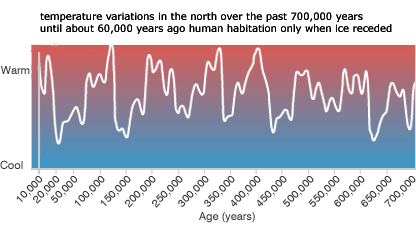
In the last two million years - the time associated with the evolution of humans, the Earth's climate became colder than before, and fluctuating more widely that before. Sudden bursts of global warming, are followed by a longer ice-age, when the temperatures are much colder than today.
The existence of ice wedges in the strata where the early stone tools were once left on the ground, shows that although it was a time of global warming, when the tools were made and used, the winters were freezing as they are today.
This region basks in hot summers - when I was there in July 1993, the afternoon temperature was a baking 36 degrees Celsius. But extremely cold winters. Even today with global warming, minus 40 degrees Celsius is normal - and it can be lower.
This has important implications. The oldest traces of permafrost at Diring Yuryakh can be linked with the general fall in temperature on Earth about 2.2 to 2.5 million years. Early humans at Diring Yuryakh must have developed sufficient technology to survive freezing winters. Humans cannot survive long at an average temperature less than 20 degrees Celsius, without adequate clothing, shelter and a source of heat.
As Mochanov pointed out, to survive in this place, humans would have needed technology to make warm clothing, light a fire, build secure homes, and hunt purposefully for food, to a more advanced level of development than that necessary for survival in warmer climates. The challenge of surviving severely cold winters would have been an important stimulus for cognitive technological development.
Extensive use of the hands for tool making and then crafts, developed the brain. The use of our hands occupies a large part of our brain. Neotony - the retention of juvenile characteristics enabled the brain to continue growing and developing for longer, giving infants more time and ability to learn survival skills from their mother. Hence the longer childhood of modern humans compared to other animals.
The smarter and most technologically advanced early humans survived and passed on learned skills.
Without the skills necessary to make clothes, warm housing, maintain a fire and store food, survival at this latitude would have been impossible. This has led to claims that Northern and Central Asia, rather than Africa must be called the "Cradle of Mankind". Which also ties in with the two million year old homo erectus remains found in Java - separated from the mainland two million years ago and the finds in the Caucasus from about that time - plus the homo erectus finds in Vietnam and China dated to more than a million years ago.
Potassium-Argon dating carried out in Novosibirsk, gave a date around a million to 1.2 million years ago for the early site at Diring Yuryakh.
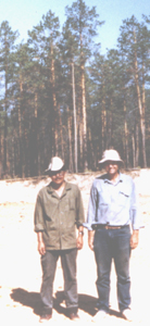 When I was there, in late July 1993, I met Michael Waters from the University of Texas who was taking samples of the infill in the ice wedges, to be tested in the USA. The Yakut and American archaeologists kindly posed for a photo for me on the site of the early finds.
Thermoluminescence tests of the samples carried out by Steven Forman and James Pierson in the University of Illinois Chicago, dated the site as at least 260,000 years old. The results were finally reported in Science, Vol.275, 28th February 1997.
The tools and the way they have been made and the positioning of the tools and fragments on the site - is very similar to the site dated to 600,000 years ago at Boxgrove in Sussex.
Like Diring Yuryakh (which means Deep Spring), the site at Boxgrove was also by a spring near a beach. The pool fed by the spring would have attracted the animals coming to drink the water. The hunters needed only to wait, with their equipment ready. They had wooden spears with fire-hardened points. (Some from about this period have been found in Clacton, and in Mauer, Germany). And they carried the stones with which they would knack out the freshly sharp butchering knives after the kill.
After the kill, each hunter then sat down to knack out his butchering knives. This left a characteristic distribution of stone chips.
A site dated to about 250,000 years ago which was in a similar situation to Diring Yuryakh - sandy river banks, has recently been excavated in Kent. The tools reveal advanced cognitive skills of these people who are thought to be ancestral to the Neandertals.
Another site dated to 400,000 years ago in Kent, reveals that these early humans must hae lived in sizable communities as they slaughtered elephants twice the size of present day elephants and butchered them with their flint tools to share out. They also killed and butchered other large animals such as horses. The animals were killed with wooden spears with fire-hardened points. Here is still more evidence for early humans living in the northern parts of the world, and how they survived.
Hunter gatherers favoured sandy river banks to live at least in the summer months - such a place was a rich source of food - here they were able to catch not only animals coming down to drink the water, but the large water birds like ducks and geese, and of course the fish.
Unfortunately no organic remains appear to have survived from the early levels at Diring Yuryakh. There are other sites of early humans in the Far East, not only in Siberia but in Northern China - where they also had to survive freezing winters. Recent dating showed such a site was more than a million years old. The site at Zhoukoudian near Beijing, was thought to date from half to quarter million years, but new dating techniques using aluminium and beryllium isotopes have now dated this site back to about 800,000 years ago - (which is also the date for the remains of wood dwellings in Japan). The site at Happisburgh, Norfolk, has been dated to 700,000 years ago. These early humans were more robust than modern people, had larger brains than their ancestors, but still smaller in capacity to modern brains. They built their shelters in caves around hearth fires which were maintained for hundreds of years, and were used for cooking food. At Zhoukoudian, human skulls had been used as bowls.
There is a similar winter shelter in the South of France - Terra Amata. And a summer shelter near the beach made of wooden poles. A shelter like this has been found in Japan and dated to 800,000 years ago.
In south-east Britain evidence has been found for human settlement from 700,000 years ago at the site at Pakefield, near Lowestoft, in Suffolk now on the east coast, more than 30 flint tools recently excavated. But at times when the climate got so cold that ice fields covered most of Britain - the inhabitants either went south or perished. This is no doubt a similar story to human settlement in North-East Siberia. When the weather was milder - then people moved north after the herds of edible animals - when it was colder they struggled to survive the changing conditions. And the extremes of climate chance over the centuries from steamy tropical with elephants to icy arctic with mammoths, would have been an impetus to evolution and developing technology.
Stone tools have now been found in Norfolk dating to nearly a million years ago. This shows that early humans were able to live in a cooler climate at that time and had the technology to assist them to do so. They appear to have control of fire and able to make some sort of shelter. They may have migrated south in autumn, as later hunter-gatherers in this part of the world are known to have done, as they appear to be similar to their contempararies living in Spain at that time.
It is therefore not at all impossible that more discoveries may still be made of very early humans in Siberia.
Remains of early human ancestors dated to almost two million years ago have been found in the Caucasus (Georgia), and in Eastern Java, so it is entirely possible that others were living in other places on this continent.
Another species of human was found when the DNA of the remains of a young girl taken from a finger and tooth, discovered in the Denisova cave in the Altai Montains in 2008, together with contemporary ornaments and jewellery from about 40,000 years ago. It has now been confirmed (published in Nature 22nd December 2010) that she was a member of a different species which lived in Asia at the same time that the Neanderthals lived in Europe and West Asia. Traces of this genome have now been found in people to the North and East of Australia, in Papua/New Guinea and the islands of Melanesia - as much as about 5 per cent of the Melanesian DNA. It is clear that these people were once much more widespread, are a distinct species from Neanderthals and modern humans, and more fossils are now been investigated.
Denisova DNA has now been found in people in East and South-East Asia.
That is what they say and it looks like they are right since they definitely had made their way there more than 70,000 years ago - possibly the first settlers arrived 140,000 years ago. And the descendants of some of these earliest settlers have survived.
Australia has always been separated from Asia by seas wide enough to ensure that Australia kept its separate unique plants and animals. Craft to cross even relatively narrow seas with storms, waves, and other hazards, would have to have been an advance from the craft which must have been used for millennia by then for travelling down rivers and across lakes and fishing.
Even in the ice-age when sea levels were lower, people would have needed to be able to make sea-worthy boats to cross waters populated with sharks, crocodiles and poisonous jellyfish. And have some idea of navigation as well and known the indications of approaching shores.
This is not the only evidence which challenges the current "out-of-Africa" theory of the evolution of "modern" people. By about 65,000 years ago Australia seems to have been sufficiently well populated to have caused or contributed to the extinction of many large and edible animals.
The early settlement of Australia, and connection with the early populations of South-East Asia, has also been confirmed by recent DNA testing. See also more on the story of how they were able to get a source of dna. And the other evidence - as shown in this excellent book by Steve Webb "The First Boat People".
More information has now been revealed on the navigation methods of the first Australians.
Such early finds as those at Diring Yuryakh are are of particular interest to American archaeologists - and controversial for them. Received wisdom had been it would have been impossible for humans to have survived the Arctic and to have been capable of crossing to America from Asia before 12,000 years ago. This is due to the fixed belief that humans had to walk across the Bering Straits and could have got no further into the American continent that way until the mile-thick ice cap had melted.
However there are traces of humans living in South America as much 35,000 years ago. There is evidence that people at this time and had the technology and the incentive to travel to America across the North Pacific by boat. They would be helped by the direction of the sea currents. After about 30,000 years ago, the invention of the sewing needle would have made it possible to make water-tight skin boats as used in Arctic waters until the present. But this may not even had been essential as the Aleutian islands then formed an almost continuous coastline blocking the icy Arctic winds. This is the same latitude as the channel - and was then not much colder.
Indications of human ancestry can be found not only in the fossil finds, in the DNA, but even in head lice.
People had made it across open seas from Indonesia to Australia possibly as much as 150,000 years ago, and by 70,000 years ago, Australia was well populated. Remains found in Brazil indicate that 35,000 years ago the same people or similar were living there. Recent finds dated to about 11,000 years definitely look "Australian".
By 70,000 years ago the people who lived then, were not only stronger but had larger brains than us, and had developed a concept of navigational direction. This can be seen in the deliberate orientation of Neanderthal/Mousterian ritual and burial sites. 30-40,000 years ago clear evidence has been found in a number of sites in Europe, Asia etc. of orientation with regard to the direction of the sun in dwelling places and apparent ritual sites. More on this with regard to Siberia later.
 DNA confirms that pre-Columbian Americans hailed from the North Pacific or at least are connected genetically.
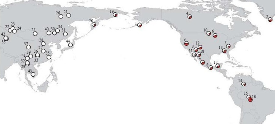
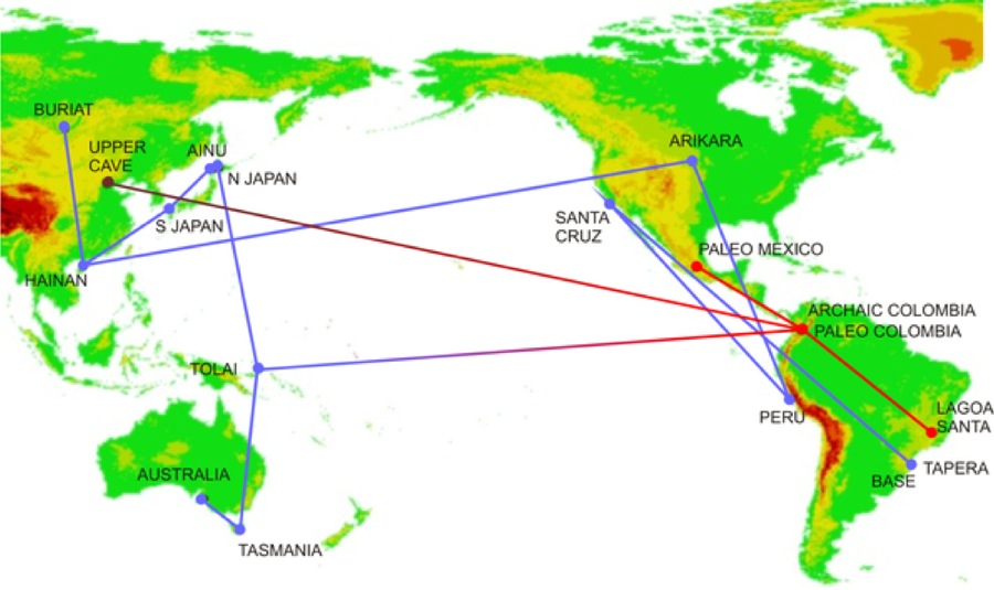 Recent studies have shown at least two completely separate migrations of populations from Asia and the Asia/Pacific regions, as shown in the diagram.
Distances are distorted on these maps and in reality are much shorter near the poles. So we can see that it would not be impossible for south Australians to have sailed to south America. In fact in the 19th century, some convicts escaped from Tasmania to Chile, in a small boat this way, winds and currents in their favour. This would explain some similarities of rock drawings, culture and appearance to Australian in Patagonia. And DNA and forensics has shown that early Sakkak Greenlanders who lived there at least from around 7,000 years ago, were related to Chukchi which indicates they had migrated across the north pacific and arctic regions from North-East Asia.
More evidence that North America was populated earlier from Siberia than previously thought.
Genetic evidence for the Siberian origins of the population of America.
 |